
LisbonSlides Project
Assessment of pathologies in buildings, natural slopes, and retaining walls located in areas susceptible to mass movements on slopes
The LisbonSlides Project aims to characterize the areas susceptible to the occurrence of mass movements on slopes.
As part of this project, a survey campaign was contracted to assess the building stock, walls and natural slopes located in unstable areas included in the 2012 PDM, with the aim of promoting an assessment of pathologies compatible with structural problems.
The final information will enable the identification of situations that require intervention and others that will require the implementation of monitoring campaigns. Both situations constitute areas for prioritizing intervention, given that slope movements are also side effects of seismic action - ReSist Programme.
This project is also interconnected with the GeoSIG project, insofar as the geotechnical information is used in the physical base model that underpins the mapping of susceptibility to mass movements on slopes, and with the AGEO project, given that the AGEO platform is intended to allow citizens to monitor the evolution of certain situations, for example walls in a poor state of repair, using a photo.
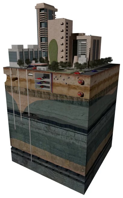
ModSub 3D project
Three-dimensional model of underground occupation
The ModSub 3D project aims to provide a three-dimensional representation of all the objects that make up the urban space underground, such as basements, tunnels and foundation elements.
This characterization makes it possible to assess the impact of buried structures on the local hydrogeological regime, but also to know the type of foundation elements and the levels at which they are located.
Figure 1 - Diagram of the main underground occupations in urban areas -
Parking, Mobility Network, Sanitation System
(Source: BGS, 2016)
BGS (British Geological Survey) (2016). Future of Cities - Development Underground.13 pp.